Cotswold Way Big Trail Adventures
Cotswold Way

Your walk from Chipping Campden to Bath

You'll walk 164 kilometres along the western edge of the Cotswolds, kept up on the limestone escarpment rather than down among the lanes, with Broadway Tower and Cleeve Hill on the high ground early and a Georgian city at the end. A route that climbs and drops all day and never quite lets you settle into a rhythm.

Distance
164 km · 102 mi
Ascent
4,300 m
Duration
3–9 days
Trips from £889pp See packages →
From per person
Plan your trip
Cotswolds UK
Trail Essentials
Start
Chipping CampdenGloucestershire
End
BathSomerset
Distance
164 km102 miles
Total Ascent
4,300 m14,108 ft
Difficulty
Moderate
Hilliness
Hilly
Time to Complete
Explorer
9 days ~18 km/day
Hiker
7 days ~23 km/day
Fastpacker
5 days ~32 km/day
Trail Runner
3 days ~54 km/day

When to Walk

Best Good Avoid
JanFebMarAprMayJunJulAugSepOctNovDec

visiting from the US

A lot of the people on this trail have flown a long way to be here, and the trail is one part of a longer trip.

We store the luggage you don't want on the walk, move what you need ahead of you each day, and shape the days around what else you've planned.

The Cotswold Way runs 102 miles from the market town of Chipping Campden to the abbey at the centre of Bath — out onto the escarpment at Dover's Hill, past Broadway Tower and over Cleeve Hill, the highest ground in the Cotswolds, down through the beech hangers above Painswick, by Neolithic long barrows and Iron Age hill forts, and into one of England's finest Georgian cities. It keeps to the western edge of the hills almost the whole way, so the views run west across the Severn to Wales while the climbs come in short, repeated bursts rather than long pulls. Most people take about a week. It rewards walkers who like a lot of small ups and downs and a good pub at the end of them. Use the planner below to build the itinerary that fits your pace.
Walking the Cotswold Way

How The Trail Unfolds

Your trail divides naturally into three parts — not by day, but by character. You start on the open northern edge with the longest views; you turn inland through the wooded, history-dense middle; and you finish on the last ridge with Bath laid out below you.

The High Edge
Chipping Campden to Birdlip

The High Edge

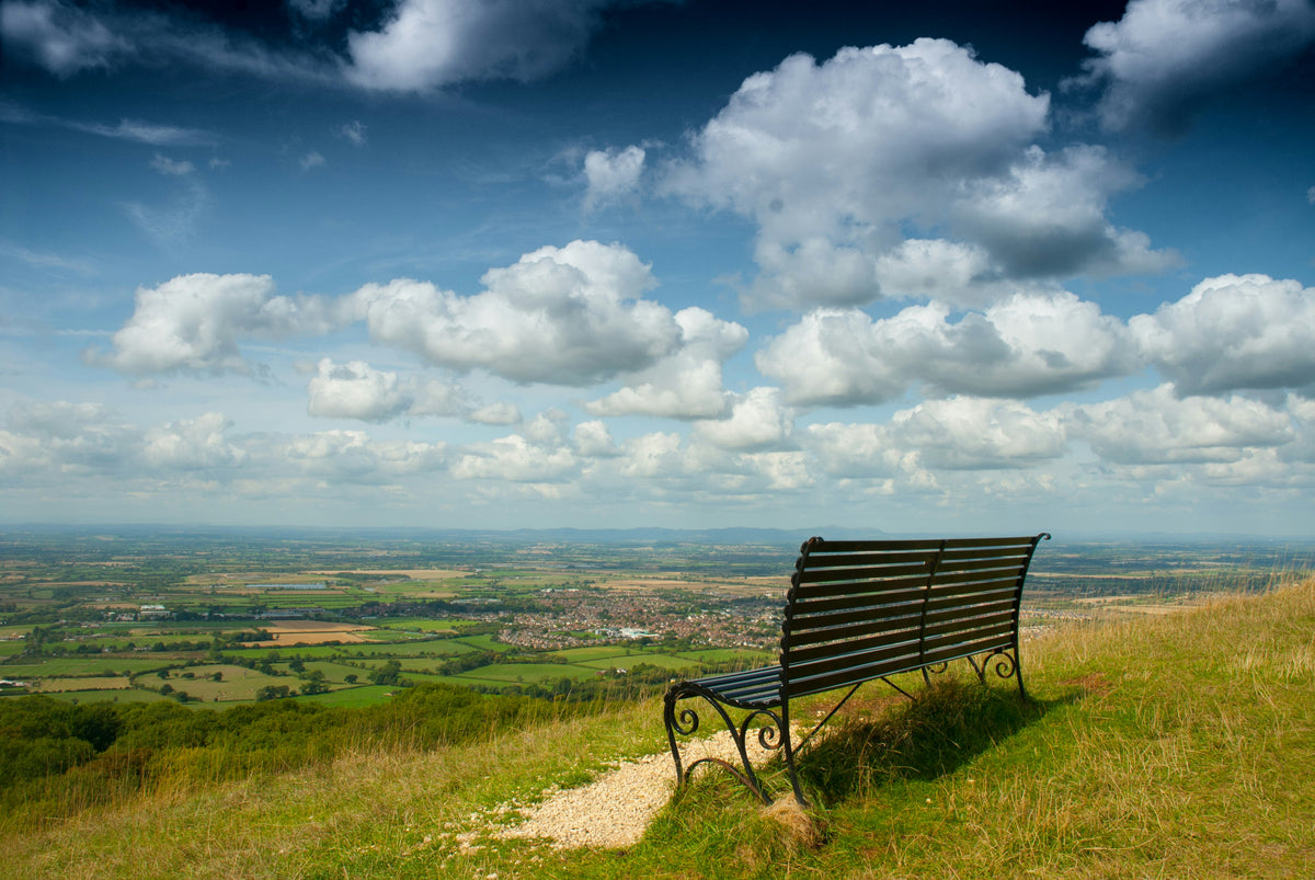
The open northern scarp, where the views run furthest and the trail's two highest points come early.

You climb out of Chipping Campden almost at once, up onto Dover's Hill and the open edge. This is the trail at its most expansive — Broadway Tower on its hill, the long pull up to Cleeve Hill and Cleeve Common, the highest ground in the Cotswolds, the Severn vale dropping away to the west with Wales on the skyline on a clear day. Grassland, drystone wall, the odd Iron Age hill fort. The walking is never flat and never level, but it's the stretch where you can see where you're going.

The Beech Country
Birdlip to Tormarton

The Beech Country

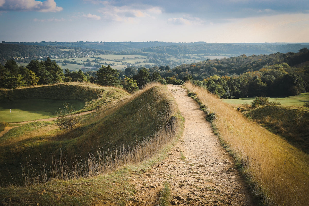
The edge turns inward — beech hangers, hidden villages, and more history packed into the hills than anywhere else on the trail.

After Birdlip the country closes in. You drop through the beech hangers above Cooper's Hill, past the slope where they still roll a cheese down it once a year, and into Painswick — churchyard, clipped yews, honey stone. This is the trail's quiet, dense middle: Neolithic long barrows, Iron Age forts at Haresfield and Uley, the Tyndale Monument on its hill, Dyrham in the valley below. Fewer big views, more trees, and a steady rhythm of short climbs and drops you stop counting somewhere around Wotton-under-Edge.

Down to Bath
Tormarton to Bath Abbey

Down to Bath

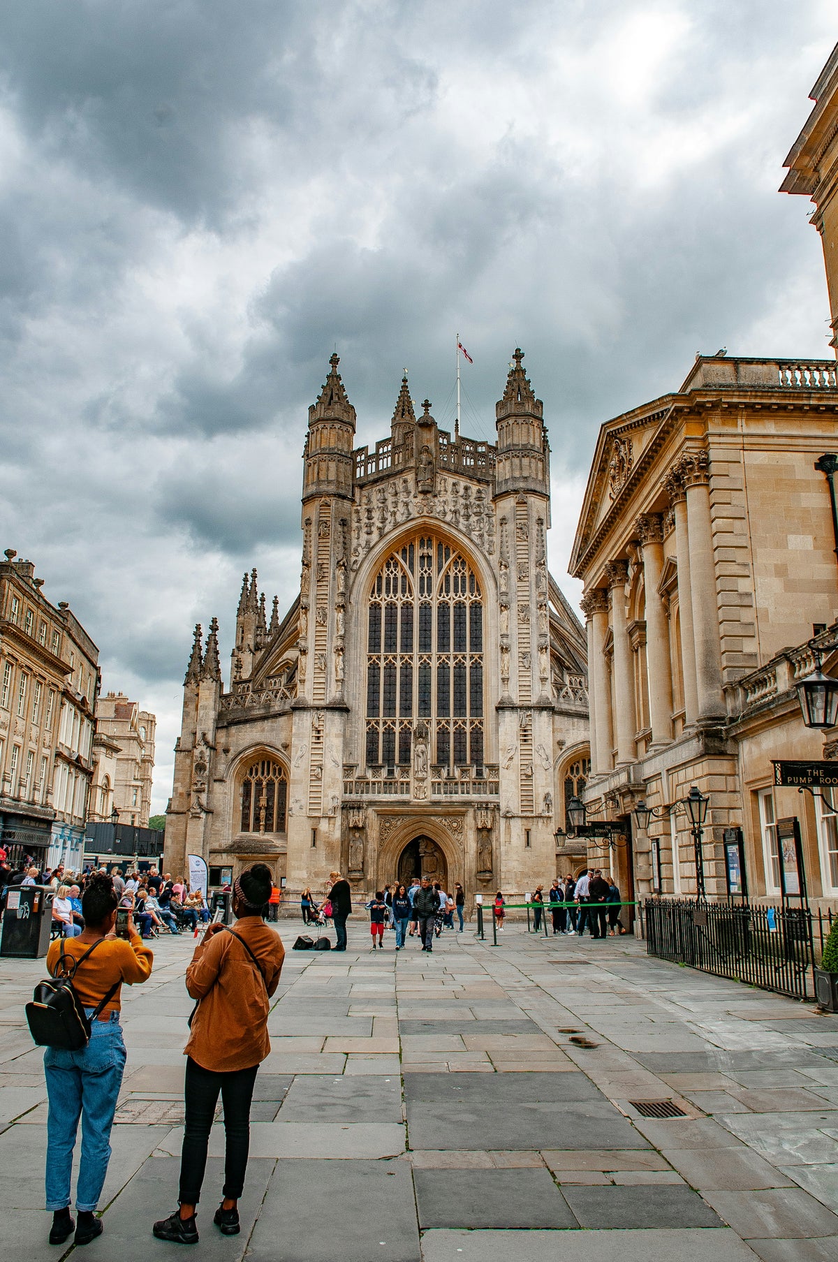
The last ridge, the first sight of the city, and a Georgian finish you walk straight into.

The final stretch runs the ridge above the Battle of Lansdown site before Prospect Stile, where Bath shows itself for the first time, laid out in its valley below. Then you walk down into it — past Beckford's Tower, the Royal Crescent, the Palladian bridge at Prior Park — and finish at Bath Abbey, at the second of the trail's two carved stone markers. After three days of woods and ridges it's an abrupt change: one moment hill pasture, the next a World Heritage city. A good place to stop walking.

— Now Make It Yours —

Find Your Cotswold Way

Most people walk it in 7 days. Some want longer to take it all in. Others want the challenge of doing it quicker. Pick the trip that suits you — or customise yours below.

ABTOT 5690 · Financially protected Guidebook authors on every trail 72-hour confirmation or no charge Refund promise if we can't deliver
Your personalised Trail Book — trip overview, day by day itinerary and accommodation details

Included with every trip

Your personalised
Trail Book

Everything you need for every day of your trail — built around your exact itinerary. Your route, your accommodation, your packing list. Ready before you leave, works offline when you're out there.

Tonight's accommodation

Check-in time, room type, phone number and directions — all in one place

Day-by-day trail description

Route map, elevation profile and written description for each stage

Packing list and pre-trip checklist

Everything you need, nothing you don't. Tick items off as you go

Works offline

Open it once with data and it's yours — no signal needed on the trail

Included with every trip

Your route on every device you use

Your custom GPX file is built around your exact itinerary — day by day, door to door. Load it onto any device or app before you set off and navigate with confidence.

Works with

GPX route on Komoot iPhone app and Garmin watch
You Can't Plan for Stanton

Hear it from the trail

Jennifer Stevens

Jennifer Stevens walked the Cotswold Way in August: 102 miles, seven days, 30-degree heat. She came back talking about shin-kicking tournaments, a field of unexpectedly friendly sheep, and why tame trails can still surprise you.

“"I actually truly fell in love with that place. I got there and it was silent. There was no one else there. I actually wanted to cry. It was so nice."”
Read Jennifer’s story →
Craig, Trail Specialist at Big Trail Adventures
Talk to a Specialist

Knows the trail. Plans yours.

Craig Trail Specialist
The Cotswold Way is the one I point people to when they've done a coastal path and want something with more history per mile and a proper city at the end. Don't be fooled by 'the Cotswolds' — it's a lot of up and down. Give it seven days, not five.

Craig has spent over ten years in adventure travel — most of it talking walkers through trails like this one. He's helped hundreds of people plan their Cotswold Way, knows where they underestimate the cumulative climbing on a trail that looks gentle on paper, and has the calls in his pocket from people who walked it the week before.

Ask Craig about the Cotswold Way

If you want to talk through your timing, your fitness, your pace, or anything the planner can't answer — call. Most of our customers do, and Craig's the one who'll answer.

The Practical Side

Before You Book

The things walkers ask us most often — answered plainly, so you don't have to ring to find out.

How fit do I need to be?

You'll want to be comfortable walking around 22 to 24 km a day with a daypack. The Cotswold Way looks gentle on a map, but the climbing adds up — roughly 4,300 m of ascent over the route, almost all of it in short, steep escarpment pulls rather than long mountain climbs. There's no single hard day, but there are a lot of moderately hard ones. If that sounds much, the Explorer pace spreads the same distance over nine days.

When should I walk it?

May to September is the best window. Late spring and early summer — May and June — give you long days, dry paths, and the beech woods and grasslands at their best. September is quieter, with settled weather and autumn colour. August is the busiest month, and accommodation in the smaller villages books up early. Winter brings the clearest views from the edge but heavy, sticky going underfoot and short days.

Do you include luggage transfer?

Yes — your bag is moved between accommodations every walking day, up to 20 kg per bag. You walk with a daypack carrying the day's essentials. The Cotswold Way stays close to roads and villages for almost its whole length, so there are no remote stages where transfer is a problem.

What kind of accommodation do you book?

Family-run inns, B&Bs and small guesthouses in the Cotswold towns and villages along the route — never chains. Every stay is en-suite, with breakfast included and somewhere to dry wet boots. On this trail that means places in towns like Broadway, Winchcombe, Painswick and Wotton-under-Edge, with the occasional village where options are limited and we book early.

Can I walk it solo?

Yes — the Cotswold Way is one of the more solo-friendly National Trails. It's well waymarked in both directions, the villages are close together, and you're rarely far from a road or other walkers, especially in summer. We book single-occupancy rooms, with a single supplement on the smaller places where a single room isn't available.

What's the realistic total cost?

Our Classic package starts at £889 per person for the seven-day Hiker pace, based on two people sharing. That covers accommodation, breakfast every morning, baggage transfer, a route pack with maps and notes, and 24-hour support. On the trail, budget around £25 to 35 a day per person for lunches, drinks and the odd entry fee if you stop at places like Sudeley Castle or Prior Park.

Still not sure? Ring us on 0131 560 2740 — Craig usually answers.

Still Thinking?

Speak to Craig

If you've scrolled this far, we need to help you get onto this trail. The bit the planner can't help with — "is the pace right for me?", "is August really that busy?", "can we add a rest day in Keswick?" — that's a two-minute phone call. Most people who book the Cotswold Way ring first.