No video has been set for this product.
Pembrokeshire Coast Path Stage 2: St Davids to St Dogmaels Overview
- Wild headlands above inaccessible coves and inlets
- Pretty villages and sandy beaches with rich history
- Most challenging Pembrokeshire Coast Path section with steep hills
The section of the Pembrokeshire Coast Path between St Davids and St Dogmaels offers one of its most spectacular sections. Celebrated for its rugged beauty and unspoiled landscapes, this stretch is a highlight of the 186-mile-long path, which is famed as one of the world’s finest coastal walks. This section of the trail traverses dramatic cliffs, secluded coves, and sweeping bays, showcasing the wild, untamed character of the Pembrokeshire Coast National Park—the UK’s only coastal national...
| Hilliness | |
| Start Point | Pembroke |
| End Point | St Davids |
| Activity Type | Walking, Hiking, Trail Running |
| Distance | 107km | 66 miles |
| Ascent | 2,024m | 2,077m |
| When to go | May to September |
| Baggage Transfer | Yes |
Custom Adventure Plan: £84.00
Book Now
Not ready to book?
Call us on 0131 560 2740
or enquire by email
What's included?
-
Custom Adventure Plan
-
Accommodation options for you
-
Door‑to‑door GPX in our app
-
On‑trail support
-
Share with up to four people
Gallery
Sample Itinerary
Here's what's on the trail. We'll split the stages to each day just right for your pace.
The trail starts in St Davids, heading south to St Non’s Chapel, the legendary birthplace of St David, featuring a holy well and a modern chapel built from salvaged ruins. The coastal path then winds past dramatic cliffs with views of Ramsey Island, often dotted with seals. Next is Porth Clais, a historic harbour with a seasonal café and facilities.
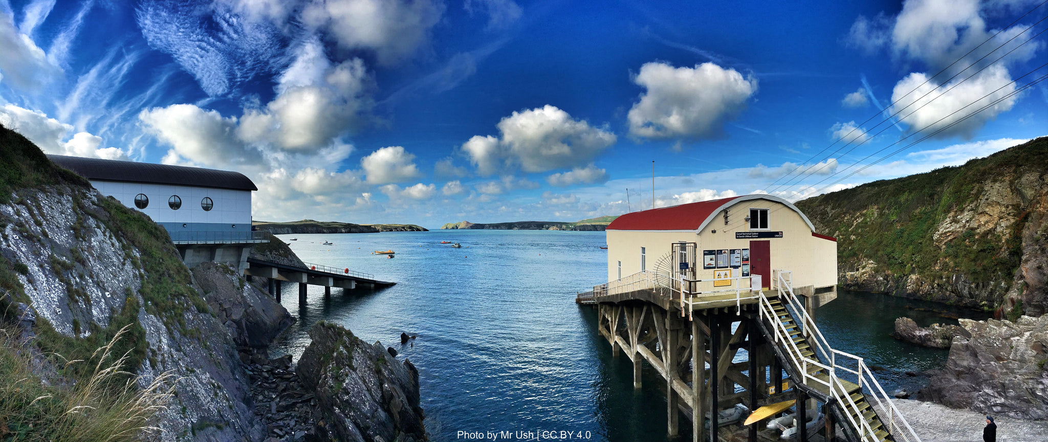
The route continues to St Justinian, home to a lifeboat station and boat trips to Ramsey Island. Wild ponies graze the headland, maintaining rare flora, while seals bask in the coves below. The path ends at Whitesands Bay, a stunning golden beach backed by cliffs and Carn Llidi peak. Facilities include toilets, a café, and a summer shuttle bus to St Davids.
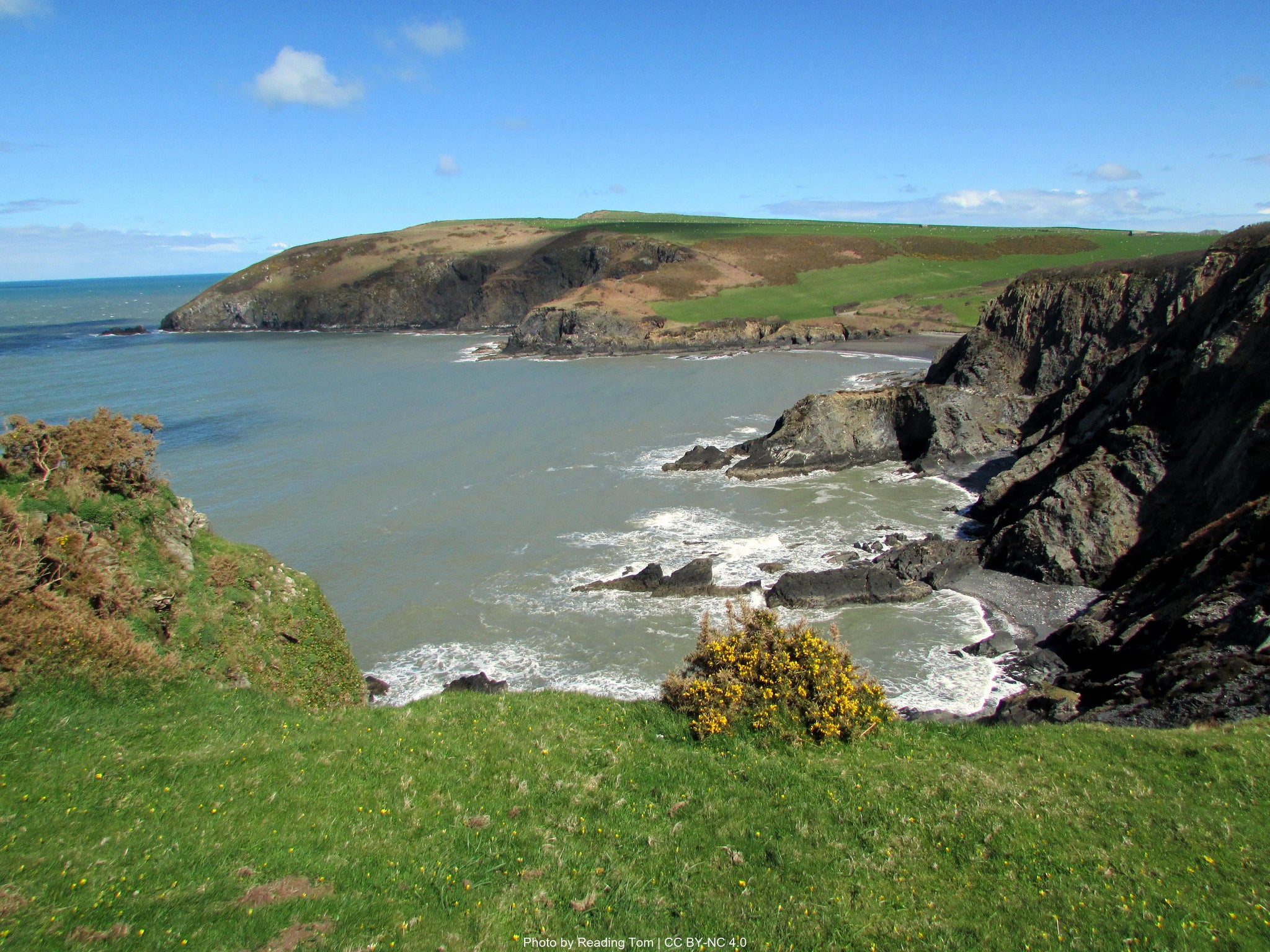
From Whitesands Bay, the trail climbs past secluded coves like Porth Melgan before reaching the wild St David's Head peninsula, where Iron Age ruins and the 6,000-year-old Coetan Arthur burial chamber stand amid dramatic cliff-top views of Ramsey Sound and the Bishops and Clerks rocks. Seals often bask in the coves below while gannets and porpoises hunt offshore. The path continues to the peaceful cove of Aber-pwll before arriving at Abereiddy's striking Blue Lagoon, a flooded slate quarry with vivid blue-green waters, where public toilets and a seasonal ice cream van are available. Nearby Porthgain reveals its industrial past through massive brick hoppers, now complemented by excellent dining options like The Sloop Inn pub and The Shed's renowned fish and chips. Further along, the ruins of historic Trefin Mill mark the way to Abercastle, a picturesque fishing hamlet with harbour-side toilets, while walkers can detour uphill to Trefin village for refreshments at The Ship Inn or The Mill café.
From Abercastle, the coastal path climbs above dramatic cliffs through some of Pembrokeshire's most remote stretches, passing secluded Pwllstrodur beach before reaching the unspoiled twin beaches of Aber Mawr and Aber Bach. These tranquil pebble coves, backed by freshwater marshes, are prime seal-watching spots, especially in autumn when grey seals haul out on the shingle. A worthwhile 1km inland detour leads to Melin Tregwynt Woollen Mill, where a café serves breakfast, lunches, and local baked goods daily (Monday-Friday 9:30-17:00, weekends 10:00-17:00) - the only refreshment stop in this isolated area.
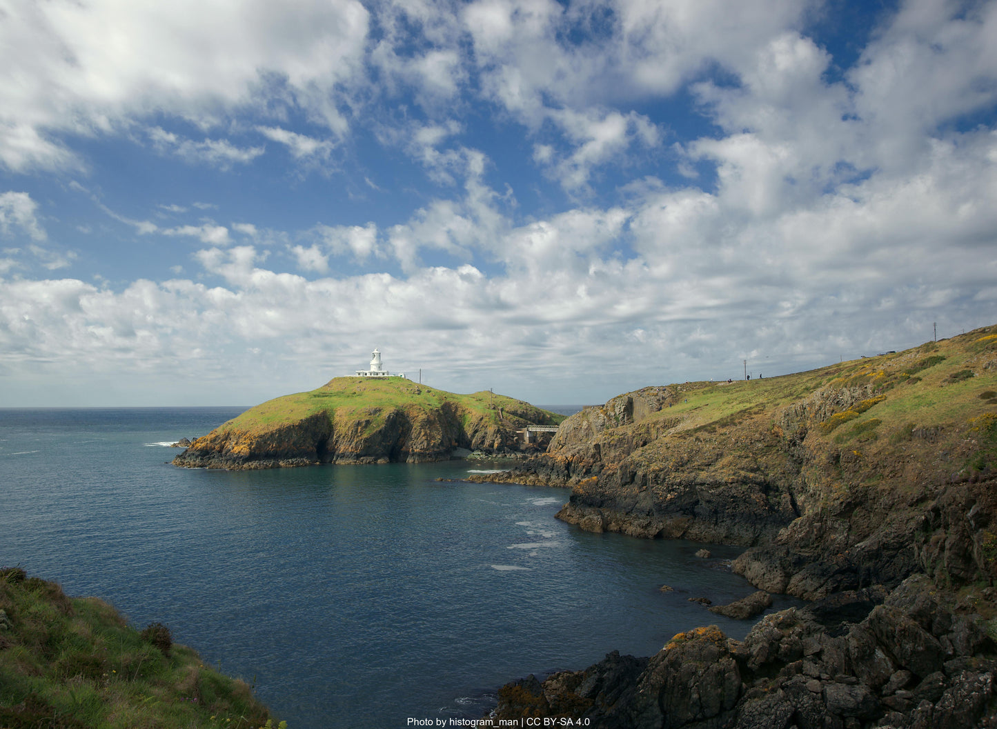
The landscape grows increasingly spectacular as the path approaches Pwll Deri, with towering cliffs at Pwllcrochan giving way to the seal-frequented cove of Porth Maenmelyn. Passing the ancient Iron Age fort of Dinas Mawr, the route climbs past volcanic hillocks and the sheltered valley of Pwll Arian before reaching the dramatic headland of Strumble. Here, the 1908 lighthouse stands sentinel on Ynys Meicel island, offering panoramic sea views and exceptional wildlife spotting - from resident seals and porpoises to migrating dolphins, whales, and seabirds like fulmars and guillemots.
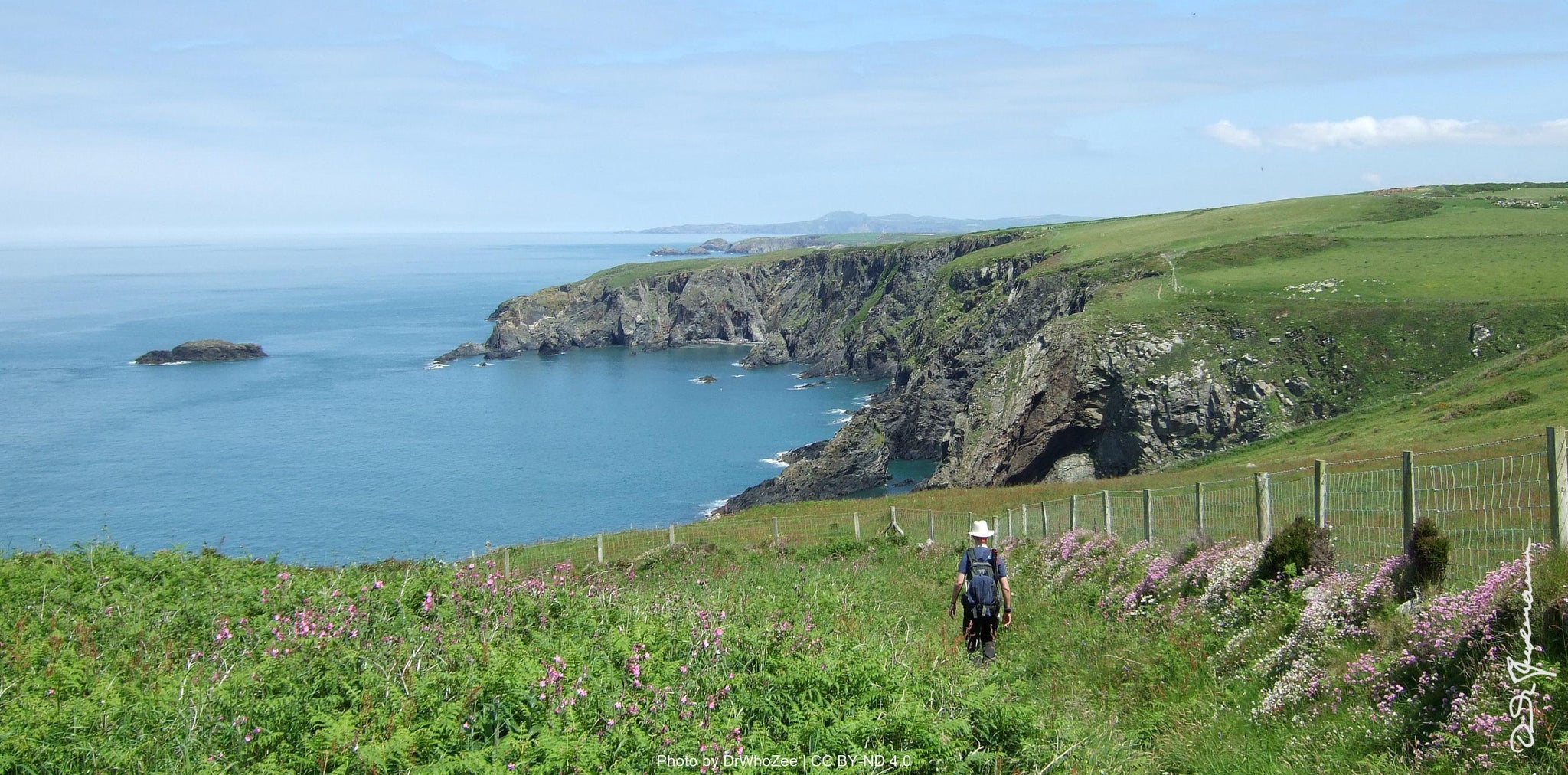
East of Strumble Head, the path traces breathtaking clifftops with views to Cemaes Head, passing remote bays and the isolated Penrhyn holiday cottage. At Carregwastad Point, a monument marks Britain's last invasion site, where French forces landed in 1797 before surrendering at Goodwick. The final stretch winds through the wooded Cwm Felin valley before descending to Goodwick's amenities, completing this wild section of coastal walking.
The trail departs Goodwick Harbour into one of Pembrokeshire’s most challenging stretches—20km with steep climbs and no facilities until Newport. Passing Lower Town’s ancient volcanic cliffs, it reaches Fishguard Fort, where the Royal Oak Inn displays artifacts from Britain’s 1797 invasion. The path then traverses sheltered hedgerows before ascending exposed clifftops with 470-million-year-old rock formations.
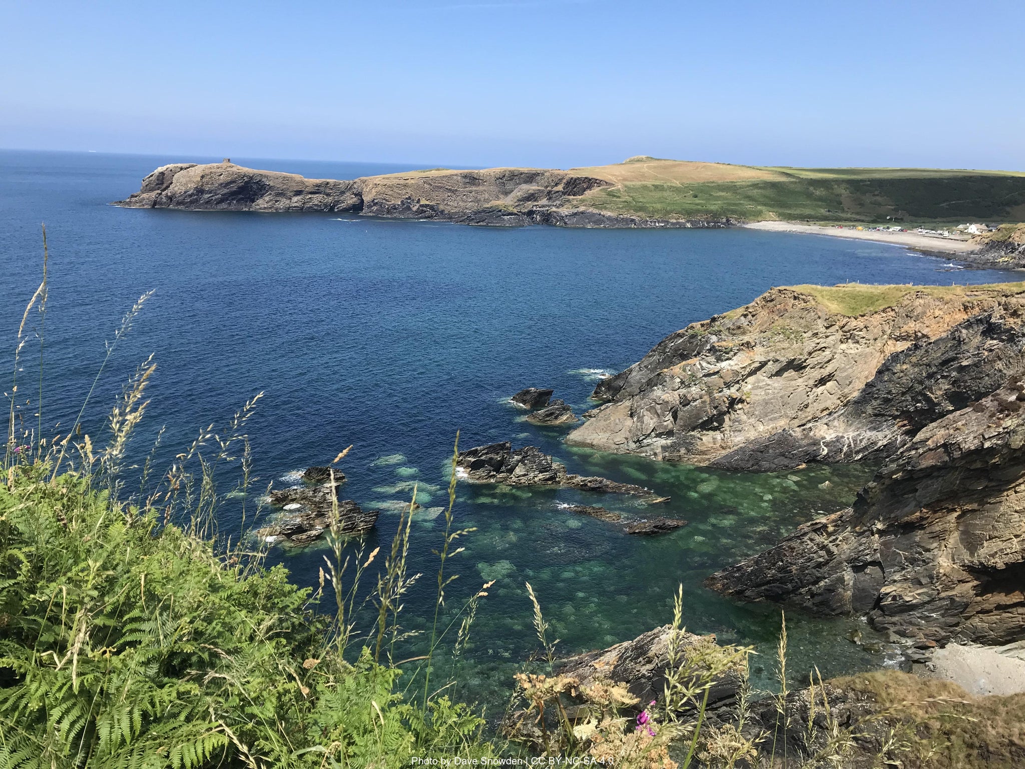
A steep descent leads to Pwllgwaelod’s cove (The Old Sailors Pub, toilets) and a detour to Bryn-henllan’s gallery-café. Walkers can shortcut across Dinas Island or tackle the full route around Dinas Head, summiting Pen-y-Fan (142m) for views of Cardigan Bay and the Preseli Hills. Seabirds nest along cliffs overlooking Needle Rock.
The path drops to Cwm-yr-Eglwys, where storm-wrecked St. Brynach’s Church ruins stand, then winds past Aber Bach’s pebble beach to Newport Sands (toilets, showers, seasonal café). Finally, Parrog’s historic harbor offers waterfront dining at Morawelon Café, while Newport town provides pubs, shops, and resupply options.
The 20km stretch from Newport to Poppit offers no en-route refreshments, demanding proper preparation. The trail begins gently along the River Nevern before climbing steep cliffs—accumulating over 915m of ascent—past Pembrokeshire’s highest coastal drops. Highlights include the thunderous Witches’ Cauldron blowhole and Ceibwr Bay’s folded rock formations, where seals gather August-November. A 1km detour leads to Moylgrove’s toilets and Penrallt Garden Centre café, with infrequent buses to St Dogmaels (timetable: pembrokeshire.gov.uk/bus-routes).
The path’s toughest challenge comes at Pwllygranant ravine before revealing Pen yr Afr’s spectacular geological folds. Victorian coastguard ruins crown Traeth Godir Coch, offering dolphin-spotting vistas. Cemaes Head’s 175m cliffs host Wales’ largest grey seal colony and nesting seabirds. Approaching Poppit, dunes lead to the Blue Flag beach (toilets, Crwst café). The finale at St Dogmaels features the Ferry Inn’s endpoint marker, 12th-century Y Felin watermill’s tearoom, and Coach House Heritage Centre’s Celtic stones—a perfect celebration after this dramatic coastal trek.
How long will it take?
Everyone has a different approach to trails. Here are our suggested times for the Pembrokeshire Coast Path Stage 3: St Davids to St Dogmaels for different types of adventurers.
Here we have assumed that you will be out on the trail for around 8 hours per day, including regular breaks but not extended lunch stops.

5
Days
For walkers who love the journey as much as the destination.
You enjoy full days on the trail, moving steadily, soaking up the scenery — with plenty of time for food and drink stops along the way!

4
Days
For long-distance walkers who enjoy the challenge of a steady pace over varied terrain.
You’ve got the fitness to cover strong distances over several days — this is where most keen hikers will find themselves.

3
Days
The first of our faster categories — built for those who prioritise pace.
You move quickly with minimal stops, carry just the essentials, and have the fitness to handle long days and tough terrain.

2
Days
Our fastest pace – ideal for those used to ultramarathons.
You mix fast hiking with running on flats and descents, even over mountains. Speed and efficiency matter most, with minimal stops as you aim to complete each route as quickly as possible.
Essential Travel Information
Best hiking season: May through September provides optimal conditions, with May-June and September offering the best balance of good weather and manageable crowds. The coastal location moderates temperature extremes, but exposes walkers to weather systems and strong winds.
Weather patterns and challenges: The Pembrokeshire coast experiences a maritime climate with mild winters and moderate summers. Rainfall occurs throughout the year but can be heavy, even in summer. Sea mists can develop rapidly, particularly in early morning and evening hours. Wind exposure is significant on clifftop sections.
Seasonal hazards include:
- Muddy and slippery paths after rain, particularly on exposed cliffside sections.
- Temporary closures of sections of path due to erosion or conservation work.
- Tidal crossings can affect some areas, though detours do exist.
Timing of facilities/refuge openings: Most coastal accommodations, cafes, and visitor facilities operate fully from Easter through October but smaller hostels and campsites may close from late autumn through to early spring. Plan accordingly.
The Pembrokeshire Coast Path offers exceptional accommodation variety along its length:
B&Bs/Guesthouses: £60-120 per night (double room), representing the most common and reliable option. Walker-friendly establishments typically offer packed lunch services, drying facilities, and early breakfast options.
Hotels: £120-200+ per night, available in larger coastal towns like Tenby, Milford Haven, Pembroke and St David's.
Bunkhouses/hostels: £18-40 per night (dormitory bed), strategically located at key points including Broad Haven, St Davids and Manorbier. YHA properties offer excellent walker facilities and represent outstanding value.
Bunkhouses/Hostels: £25-45 per night, basic but clean dormitory-style accommodation popular with budget-conscious walkers and groups.
Booking requirements and timing: Advance booking is absolutely essential during peak season (June-September), particularly for weekend dates and in smaller coastal villages with limited options. Book at least 4-6 months ahead for summer trips, with some popular establishments filling up to a year in advance.
Popular stopover points: Key overnight locations include Tenby, Manorbier, Pembroke, Solva, St Davids, Fishguard and St Dogmaels.
Nearest airports/major cities:
- Cardiff Airport (2 - 2.5 hours to Amroth or Pembroke)
- Bristol Airport (3 hours to Amroth or Pembroke
- Major cities: Cardiff, Bristol, Swansea (1 - 1.5 hours to Amroth or Pembroke)
Public transportation options:
- Swansea: direct service to Pembroke (frequent services)
- Cardiff: direct service to Pembroke
- Excellent bus network connects all coastal towns
Trailhead access:
- Amroth: Start from the sandy beach
- Pembroke: Finish at Pembroke town centre
- Outstanding public transport eliminates car dependency
Evacuation points and bail-out options:
- Saundersfoot (bus links)
- Tenby (train station and bus links)
- Manorbier (bus links)
- Freshwater East (bus links)
Accommodation costs for a complete 4 day trek:
- Mid-range option (B&Bs/guesthouses): £80-140 per night (£320-560 total)
- Mixed accommodation (hostels/B&Bs): £60-110 per night (£240-440 total)
- Budget option (camping/hostels): £35-65 per night (£140-260 total)
Transportation expenses:
- Return train fare to/from London: £80-150
- Local buses to accommodation off-route up to £9 per day for a pass: £36
- Baggage transfer service (optional): £100 - 150 for complete route
Food and supplies:
- Breakfast (usually included in accommodation): £0-12 per day
- Packed lunch: £6-12 per day (£24-48 total)
- Evening meal: £18-35 per day (£72-140 total)
- Snacks and drinks: £12-20 per day (£48-80 total)
Additional expenses:
- Official guidebooks and maps: £35-60
- Equipment purchases/replacements: varies significantly
- Emergency fund: £200-300 recommended
Total estimated budget ranges:
- Comfort option (B&Bs, baggage transfer, restaurant meals): £600-800
- Standard option (mixed accommodation, some baggage transfer): £400-500
- Budget option (camping/hostels, carrying own pack): £250-350
The Pembrokeshire Coast Path sees moderate to high foot traffic in summer, especially near hotspots like Tenby and St Davids. Despite its popularity, much of the path retains a peaceful, uncrowded atmosphere, especially in the northern sections or during shoulder seasons..
Quieter alternatives for maximum solitude:
- Walking in late Spring, or early Autumn
- Hiking midweek rather than weekends
- Starting very early (6-7am) to avoid crowds at popular sections
- Choosing alternative inland routes where available
- Focussing on less-touristed areas like the northern coast beyond Newport
Cultural considerations: The trail passes through Welsh-speaking communities, especially in the north. While English is widely spoken, respectful engagement with the local Welsh culture and language adds to the experience.
Typical hiker demographics: Typical hikers include UK-based walkers, solo travelers, and international nature enthusiasts. While camaraderie among trekkers is common in busier months, the trail offers ample opportunity for solitude and reflection, especially during early morning or off-peak periods.
Let our app guide you
-

Our app for going off-grid
Know what to expect. Navigate with confidence. See all your details in one place.
-

Know what to expect
See al the details of your adventure in one place so you can plan each stage with confidence.
- Distance
- Ascent & descent
- The time it will take you.
- The weather forecast for each day
-
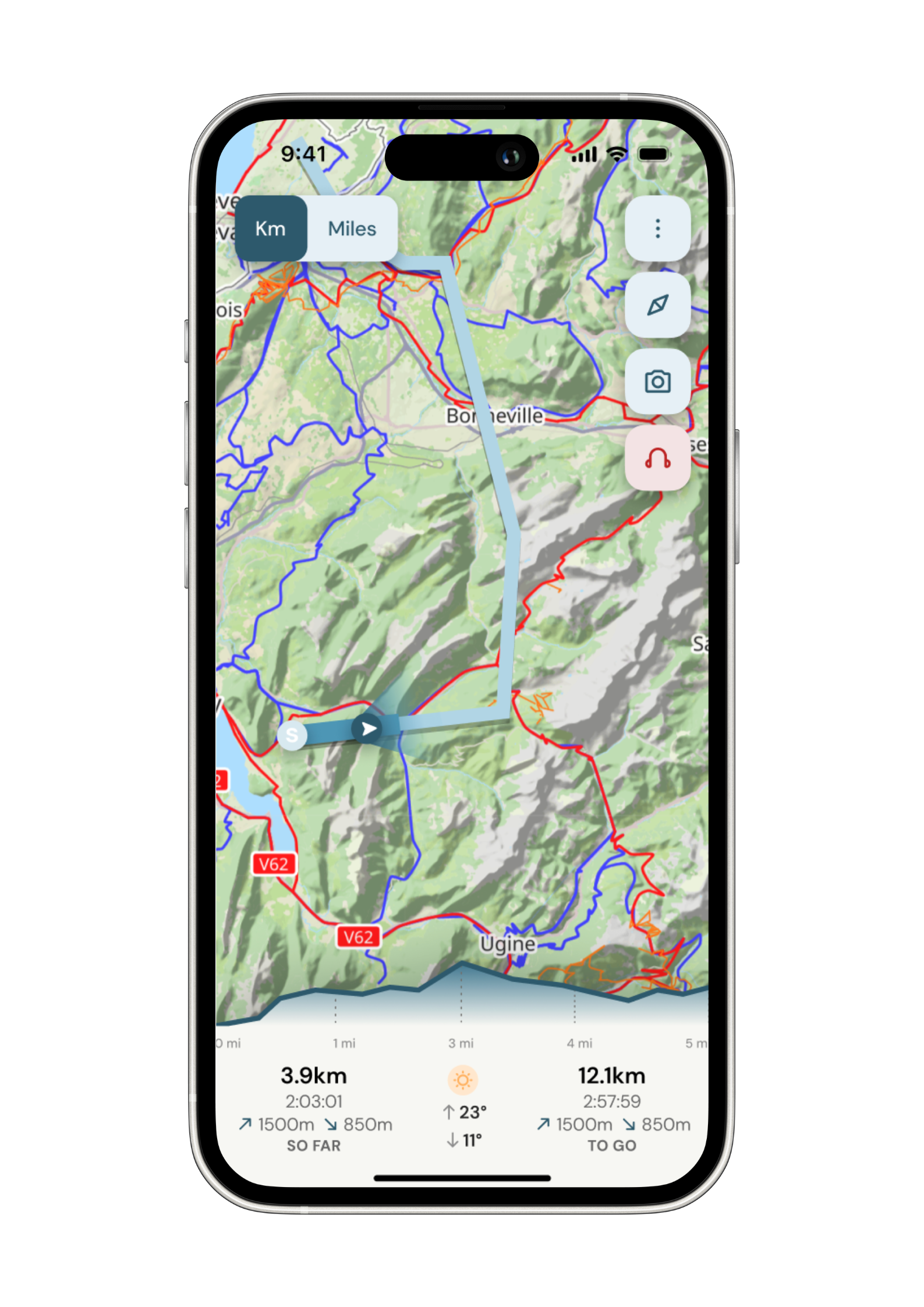
Navigate with confidence
Follow your trail on maps specifically chosen for walkers on the trail. Track your progress and get weather updates.
Need re-routing? Support is available at the click of a button.
-

Admin. In once place.
Store all the details of your accommodation in the app alongside each stage of your adventure.
No signal, no problem. Everything is stored locally.